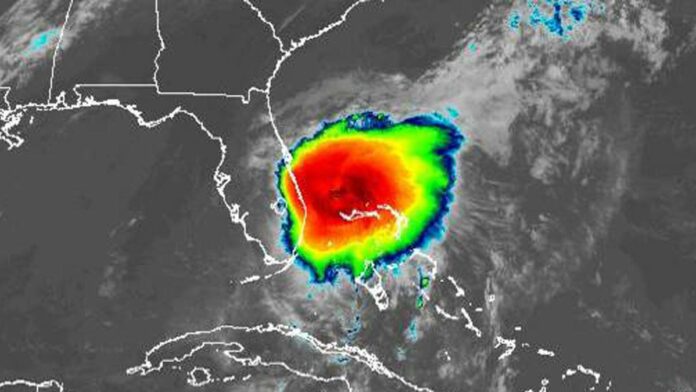
It didn’t regain hurricane strength, but Tropical Storm Isaias is still packing 65 mph winds as it moved closer to the Florida, but now the National Hurricane Center projects its center to remain off the coast.
As of 11 a.m., the National Hurricane Center said Isaias was located 55 miles southeast of Fort Pierce and 120 miles south-southeast of Cape Canaveral with tropical-storm-force winds extending out 115 miles. It’s moving north-northwest at 8 mph and forecast to skirt along Florida’s east coast today.
Earlier, the NHC had its forecast track less than a mile off of Cape Canaveral Air Force Station. Now the storm is projected to be farther out, with its center 25-30 miles from shore east of Melbourne around 8 p.m. and then turning more north overnight into Monday.
“Just a big old blob of breeze and rain,” said FOX 35 meteorologist Jayme King. “The dry air kind of spelling the demise of this late last night and keeping the intensity in check.”
He said bands that can make their way inland to Orlando could be 25-30 mph during the day, but those could increase as the storm gets closer Sunday night. During the day, wind gusts of 39 mph or higher are expected along the coast.

Tropical Storm Isaias cone of uncertainty as of 11 a.m. Sunday, August. 2, 2020. (National Hurricane Center)
South Florida has already felt the increased wind and rain from the approaching storm. A weather observation site at the Juno Beach Pier measured a wind gust of 47 mph Sunday morning with tropical-storm-force gusts up to Port St. Lucie.
As of 11 a.m. Florida’s coastal counties from Jupiter Inlet north are under a tropical storm warning. That same warning has been extended along the southeast U.S. coast to Surf City, North Carolina and a tropical storm watch from Surf City to Duck, N.C. including Pamlico and Albemarle Sounds.
A storm surge watch for Florida’s east coast has been discontinued as has the tropical storm warning from Jupiter Inlet south and for Lake Okeechobee.
Earlier forecasts had Isaias, which was downgraded from a Category 1 hurricane to a tropical storm on Saturday returning to hurricane strength, but the restrengthening did not occur overnight and it is now expected to remain a tropical storm as it passes Florida and turns north toward the Carolina coast for a potential landfall late Monday night or early Tuesday.
“Isaias appears to have missed its opportunity overnight to re-strengthen to a hurricane and will remain a strong tropical storm through Monday,” said NHC lead forecaster Scott Stripling. “Large seas and strong and very rough surf will spread from south Central Florida northward ahead of Isaias through Monday.”
Rain is expected throughout the day on Sunday, about 2 to 4 inches in some areas of Central Florida, with up to 6 inches closer to the coast.
The storm dumped rain, knocked out power and snapped trees as it lashed the Bahamas on Saturday, growing to as much as 85 mph sustained winds with stronger gusts, but lost steam dropping to tropical storm strength of 70 mph by 5 p.m. It reduced even more by 5 a.m. Sunday as it made its way toward South Florida.
NHC director Ken Graham on Saturday warned residents to not be cavalier, though, with Tropical Storm Isaias.
“When you have tropical-storm-force winds, it’s just too dangerous to be outside,” Graham said.
Florida Gov. Ron DeSantis also urged preparedness and advised Floridians to have seven days’ worth of food, water and medicine on hand. The governor declared a state of emergency Friday for all of Florida’s east coast counties from Monroe to Nassau ahead of Isaias’ arrival.
“The most important thing we want people to do now is stay vigilant,” DeSantis said Saturday.
The governor also announced his request for federal assistance had been approved by President Donald Trump.
“The response to Hurricane Isaias comes after five consecutive hurricane seasons in which the State has been impacted by multiple million, and in some cases, multiple billion-dollar storms, all while in the midst of the largest disaster event managed by FEMA and the State of Florida, the COVID-19 Pandemic/Public Health Emergency,” DeSantis wrote to the president.
The approval means the Federal Emergency Management Agency will provide reimbursement for expenses related to weathering the storm.
The presence of the storm didn’t stop NASA from its plans to bring home two astronauts from the International Space Station. Bob Behnken and Doug Hurley departed the ISS on the SpaceX Crew Dragon capsule dubbed “Endeavour” on Saturday with plans to splash down in the Gulf of Mexico near the Florida Panhandle at 2:48 p.m. EDT Sunday.
Isaias has already been destructive in the Caribbean: On Thursday, before it became a hurricane, it uprooted trees, destroyed crops and homes and caused widespread flooding and small landslides in the Dominican Republic and Puerto Rico. One man died in the Dominican Republic. In Puerto Rico, the National Guard rescued at least 35 people from floodwaters that swept away one woman, whose body was recovered Saturday.
The NHC was also tracking a tropical wave in the Atlantic a few hundred miles east of the Leeward Islands. Forecasters give that storm a 30% chance of forming into a tropical depression or storm in the next two days, with better odds of 60% over the next five days.
The 2020 hurricane season already has seen seven tropical storms: Arthur, Bertha, Cristobal, Dolly, Edouard, Fay, Gonzalo, plus Hurricane Hanna, which hit Texas last weekend, and now Isaias. The next named storms would be Josephine, Kyle, Laura, Marco, Nana, Omar, Paulette, Rene, Sally, Teddy, Vicky and Wilfred.
As a public service, the Orlando Sentinel is now offering free, unlimited access to hurricane coverage on our website.
Orlando Sentinel staff reporters Joe Mario Pedersen, Paola Pérez and Matthew J. Palm and The Associated Press contributed to this story.


