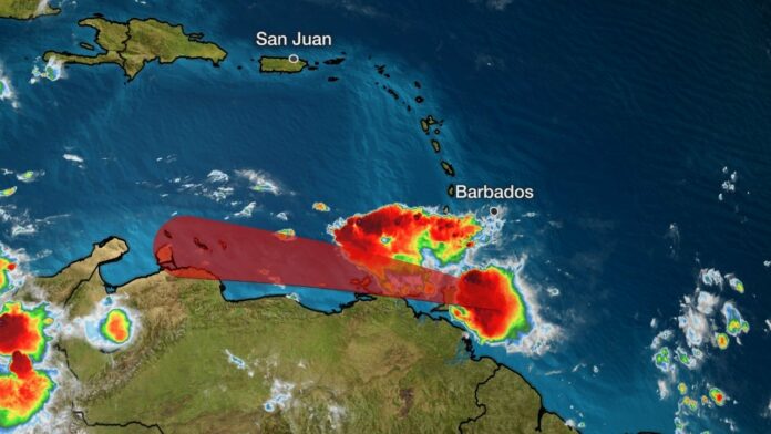
- Tropical Storm Gonzalo is nearing Trinidad and Tobago.
- It’s expected to sweep through the southern Windward Islands Saturday.
- It is a very small storm, so its impacts will be minimal.
- Flooding rain, high winds, high surf and coastal flooding are all possible in parts of the Windward Islands.
- Gonzalo is the earliest seventh named storm to form in the Atlantic.
Tropical Storm Gonzalo is headed for the Windward Islands Saturday, but weakening is expected as the storm moves into the Caribbean. Some islands may receive gusty rain showers as Gonzalo passes through.
Gonzalo’s center is located just east of Trinidad, moving west fairly quickly.
The map below shows the latest watches and/or warnings issued for Gonzalo in the southern Windward Islands. A warning means those conditions are expected in the next 36 hours.
(MORE: Hurricane Season Terms You Need to Know)
Current Watches and Warnings
Hurricane hunters have found a weakening tropical storm in a flight Friday evening, with winds of largely in the 30-40 mph range.
Gonzalo’s tiny size and the environment around it are keeping the storm weak and disorganized. You might have to squint to pick up the size of its tropical-storm-force winds shaded orange in the graphic below.
Gonzalo’s Current Wind Field
(The orange circle shows the extent of the system’s tropical-storm-force winds (at least 39 mph). The purple circle indicates the extent of hurricane-force winds (at least 74 mph), according to the National Hurricane Center.)
Gonzalo has been battling dry air, which is plentiful to its north and west, shown by the orange and red colors in the satellite image below.
Its circulation ingested some of this dry air early Thursday morning, putting the brakes on its intensification, at the time.
Thunderstorms continue to look fairly unimpressive near Gonzalo’s center as it continues to fight dry air.
Water Vapor Satellite Image
(This satellite image shows areas of moist (white, pink, purple) and dry (orange, red) air in the atmosphere. The latest location of Gonzalo is shown by the white circle near the bottom of the image. )
Small storms like Gonzalo can intensify quickly in the right conditions, but they can also succumb to unfavorable conditions more quickly than a larger storm.
Once in the Eastern Caribbean Sea Sunday, Gonzalo is expected to encounter a more hostile environment of dry, stable air and possibly some increased wind shear that would suppress thunderstorms and/or blow them away from the center.
Gonzalo may also interact with northern South America this weekend.
Therefore, it’s expected to spin down to a tropical wave before affecting any other parts of the Caribbean Basin.
This Eastern Caribbean Sea “hurricane graveyard” has been shown to peak in its suppressive power in July.
Current Storm Information and Forecast Path
(The red-shaded area denotes the potential path of the center of the tropical cyclone. It’s important to note that impacts (particularly heavy rain, high surf, coastal flooding, winds) with any tropical cyclone usually spread beyond its forecast path.)
Potential Impacts
The southern Windward Islands should be prepared for a brief round of strong winds, heavy rainfall and rough surf from Gonzalo Saturday.
Flash flooding and mudslides are a concern, particularly over mountainous terrain. Wind gusts may be stronger over higher terrain, as well.
Gonzalo is the earliest seventh named tropical storm on record to form in the Atlantic basin, according to Phil Klotzbach, a tropical scientist at Colorado State University. The previous record was held by Tropical Storm Gert, which developed on July 24, 2005.
The Weather Company’s primary journalistic mission is to report on breaking weather news, the environment and the importance of science to our lives. This story does not necessarily represent the position of our parent company, IBM.


