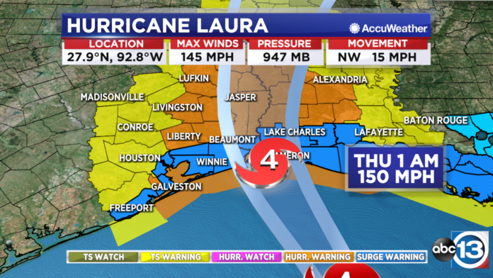
HOUSTON, Texas (KTRK) — Hurricane Laura is an “extremely dangerous” storm approaching the Texas/Louisiana coast, but Houston will likely avoid the worst of the force.
Catastrophic storm surge, extreme winds, and flash flooding are expected along the northwest Gulf coast tonight. Only a few hours remain to protect life and property.
The latest track and models are taking Laura towards the Texas/Louisiana state line near Port Arthur. Laura is continuing to gradually turn more northward. As of right now, it looks like Houston will be spared from the major impacts and power outages. It looks like we could experience gusty, possibly tropical storm force, winds and stormy weather at times from the rainbands. Our eastern cities including Winnie, Liberty, and Livingston could still experience damaging winds as the hurricane moves north onto land late tonight into tomorrow morning. Winds in these areas could reach hurricane strength with winds close to or just over 74 mph.
“Unsurvivable storm surge with large and destructive waves will cause catastrophic damage from Sea Rim State Park, Texas, to Intracoastal City, Louisiana, including Calcasieu and Sabine Lakes,” a forecast writer at the National Hurricane Center said. “This storm surge could penetrate up to 30 miles inland from the immediate coastline in southwestern Louisiana and far southeastern Texas.”
As of 4 p.m. Wednesday, Laura has strengthened to a Category 4 major hurricane with maximum sustained winds of 145 mph. It’s located 155 miles south-southeast of Port Arthur, moving to the NW at 15 mph. Minimum central pressure is at 947 MB.
Laura is zeroing in on an upper Texas coast or western Louisiana coast landfall late Wednesday night and into early Thursday morning. It’s expected to weaken some as it comes in. Landfall is expected between midnight and 3 a.m. Thursday.
SEE MORE: Hurricane categories: Learn what the numbers mean
Hurricane and Storm Surge Warnings extend from San Luis Pass and eastward along the upper Texas coast. The warnings stretch into Louisiana. Hurricane and tropical storm warnings also stretch up north through east Texas almost all the way into Oklahoma and Arkansas. A tropical storm warning is in effect for Houston.
Please keep everybody in the path of #HurricaneLaura in your prayers! People are loading up to leave Chambers County right now. Also, huge shout out to those organizing and helping keep everyone safe. THANK YOU! 👏🏽❤️🙏🏽 pic.twitter.com/G2zIZp0OxD
— Charly Edsitty (@CharlyABC13) August 26, 2020
LAURA POSITION AND TRACK
As of Wednesday afternoon, Hurricane Laura was located in the Gulf of Mexico 155 miles south-southeast of Port Arthur, Texas.
Tropical storm force winds are possible as early as Wednesday afternoon-evening. The higher chance for experiencing tropical storm force winds will be in our eastern counties including Chambers, Liberty, Galveston, San Jacinto, and Polk. Our central and western counties may experience gusty winds but they should mostly remain near to or under 40 mph.
WATCHES AND WARNINGS
A Hurricane Warning stretches along the coast from San Luis Pass to Intracoastal City, Louisiana. Chambers, Coastal Galveston, inland Galveston, Coastal Harris, Galveston Island, Bolivar Peninsula, Liberty, and Polk counties are included in the hurricane warning.
A Storm Surge Warning is in effect from Freeport, Texas, to the mouth of the Mississippi River. Galveston Island, Bolivar Peninsula, coastal Harris County, coastal Galveston County, coastal Brazoria County, Brazoria Islands and Chambers County are under this warning.
A Tropical Storm Warning is in effect from Sargent, Texas, to San Luis Pass.
Fort Bend, Grimes, Houston, Inland Brazoria, Inland Harris, Madison, Montgomery, San Jacinto, Trinity, Walker, Waller, Brazoria Islands, and Coastal Brazoria are also included in the Tropical Storm Warning.
We are entering peak hurricane season and all indications are that the already record-breaking season could get even busier over the coming weeks. Officially, the Atlantic hurricane season lasts through the end of November.
During hurricane season, remain prepared and make sure you download our ABC13 Houston app!
Here are some resources that may help you and your family get ready for this hurricane season:
- ABC13’s comprehensive video update on what’s happening in the tropics
This video is updated more frequently when threats to the Gulf are present
- Pick up the ABC13 Hurricane Tracking Guide at your local Kroger. Look for the friendly cardboard cutout of ABC13 Chief Meteorologist Travis Herzog near the store entrance.
SEE MORE: How to build a hurricane preparedness kit
Hurricane Season: Before, During and After
RADAR MAPS:
Southeast Texas
Houston
Harris County
Galveston County
Montgomery/Walker/San Jacinto/Polk/Grimes Counties
Fort Bend/Wharton/Colorado Counties
Brazoria/Matagorda Counties
SHARE YOUR WEATHER PHOTOS: Send us pics and video of weather in your area to news@abc13.com and at #ABC13Eyewitness on social media.
Copyright © 2020 KTRK-TV. All Rights Reserved.
