

- Hanna is the first hurricane of the Atlantic hurricane season.
- Hurricane force winds are likely along the Texas coast.
- The biggest danger is flooding rainfall.
- Locally heavy rain will spread across South Texas into northeast Mexico.
- That locally heavy rain will linger well after landfall.
- Rough surf and minor coastal flooding are expected along the northern and western Gulf Coast.
Hanna is now a Category 1 hurricane and is headed toward a South Texas landfall later today, with the potential for dangerous rainfall flash flooding extending well inland into northeast Mexico.
A Hurricane Warning has been issued from Mesquite Bay, Texas, southward to Port Mansfield, Texas. Tropical Storm Warnings now extend northward to High Island, Texas and southward to Barra el Mezquital, Mexico.
A Storm Surge Warning has been issued from Baffin Bay to Sargent, Texas, including Corpus Christi Bay, Copano Bay, Aransas Bay, San Antonio Bay and Matagorda Bay.
The map below shows the latest hurricane and tropical storm warnings issued. A hurricane warning means winds of 74 mph or greater are expected Saturday afternoon. A tropical storm warning means winds of at least 40 mph are expected in the next 36 hours.
Current Watches and Warnings
Hanna is tracking westward across the Gulf of Mexico toward southern Texas with a slightly slower pace than yesterday.
Radar imagery and data from the Hurricane Hunters show this system has gained winds of 75 mph, making it a minimal Category 1 hurricane. Thunderstorms have been increasing in intensity. Additional strengthening is likely before it reaches the coast Saturday.
Current Information and Projected Path
Hanna is the first hurricane of the 2020 Atlantic Hurricane season, and is roughly two weeks ahead of climatology. The first hurricane of the season generally occurs around August 10.
Thursday night, Hurricane Hunter reconnaissance mission found winds ticked up just enough to upgrade Tropical Depression Eight to Tropical Storm Hanna, the record earliest eighth named storm, beating Tropical Storm Harvey’s record, set in 2005, according to Phil Klotzbach, tropical scientist at Colorado State University. Hanna also formed before the previous record for earliest seventh storm, beating the record set by Gert on July 24, 2005.
(MORE: Why the 2020 Season Pales in Comparison to the 2005 Season)
Forecast Impacts
Heavy Rain Threat
This will be the primary concern with Hanna for much of southern Texas.
Conditions will gradually go downhill through Saturday in South Texas.
Increasingly heavier rain will arrive along parts of the Texas coast overnight Friday night into Saturday morning and continue Saturday as the center makes landfall.
Current Radar and Satellite
(Watches and warnings are issued by the National Weather Service.)
But as with most all tropical cyclones, this won’t be just a coastal event.
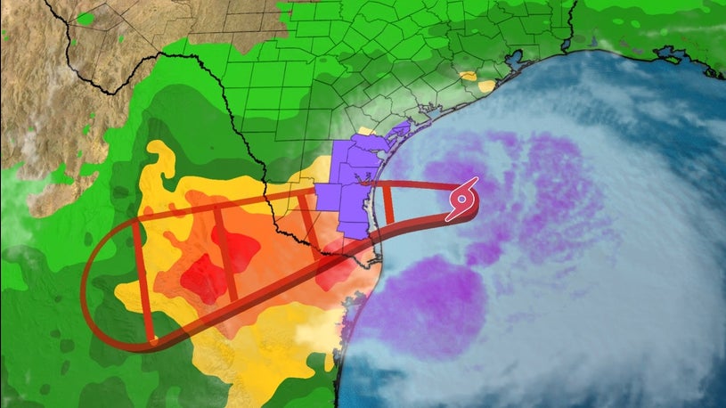
Locally heavy rain will spread well inland in South Texas into parts of northeast Mexico. This locally heavy rain could persist into Sunday, perhaps Monday, particularly in northeast Mexico.
Flash flood watches have been issued for all of South Texas and the Middle Texas Coast.
Rainfall totals of over 5 inches are possible in these areas, with locally higher amounts where bands of rain stall for a period of a few hours. A few communities could receive up to 15 inches of rainfall. This could lead to dangerous flash flooding and some river flooding, particularly in the mountainous terrain of Mexico’s Coahuila, Nuevo Leon and northern Tamaulipas states.
Rainfall Forecast
(Heavier totals are possible where bands of rain or clusters of thunderstorms stall for a few hours, which could lead to local flash flooding.
)
Winds, Coastal Flooding and Surge
Tropical-storm-force winds could develop as soon as Saturday morning and are most likely along or near the Texas Coastal Bend. These winds are capable of some tree damage and sporadic power outages.
Damaging Wind Potential
(The contours above show the chance of damaging winds (at least 58 mph), according to the latest forecast by the National Hurricane Center.)
Persistent winds blowing onshore to the east of Hanna may produce areas of high surf, rip currents and possibly some minor coastal flooding at high tide, particularly along the northern Gulf Coast.
Coastal flooding closed the bridge along Cedar Lake Road in Biloxi, Mississippi, Thursday afternoon.
Storm surge is expected from the Mexican border north to High Island, Texas, including Corpus Christi Bay, Matagorda Bay, and Galveston Bay.
Water levels may climb as much as this high during high tide through Saturday afternoon:
Keep this in mind if you’re spending time on the beaches.
(MORE: The Danger of Rip Currents)
The Weather Company’s primary journalistic mission is to report on breaking weather news, the environment and the importance of science to our lives. This story does not necessarily represent the position of our parent company, IBM.

