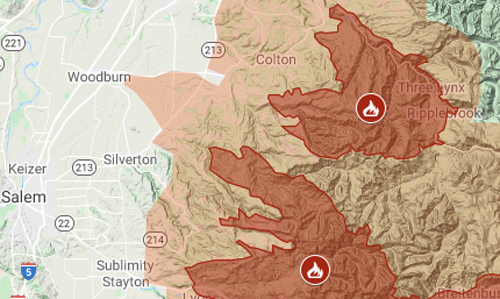
The two largest fires burning in Oregon have merged, and a third is less than three miles away.
The Lionshead Fire — which had already joined boundaries with the smaller P515 — and the Beachie Creek Fire have touched, north of Detroit Lake. The joined fire was initially renamed Santiam, but then was returned to its original names.
The Riverside Fire is expected to soon merge with Beachie Creek.
All three fires merged would be more than 450,000 acres. The heat could send embers flying long distances, potentially igniting new fires.
The mandatory evacuation zone for the three fires covered almost 2,000 square miles on Friday and extended to Portland’s southeast suburbs. It is shown in orange on the map above.
Clackamas County, which includes the cities of Sandy, Oregon City, Milwaukie and Lake Oswego, declared a curfew of 10 p.m. to 6 a.m.
For latest updates on evacuations, including warning zones, check the official maps from Clackamas County and Marion County.
The details of the three fires:
- Beachie Creek, started Aug. 16, unknown cause. Three weeks after it started, it was at only 469 acres, but the historic windstorm of Monday, September 7, whipped it overnight to more than 131,000 acres. On Sept. 11, it was 186,856 acres (291 square miles).
- Lionshead / P515, started Aug. 16 from lightning. Before the windstorm, Lionshead was 18,615 acres and 31% containment; on Sept. 11, it was 131,110 acres (205 square miles) with 5% containment. P515, connected at the large fire’s eastern tip, was 4,607 and 95% containment.
- Riverside, started Sept. 8 from unspecified “human cause.” On Sept. 11, it was 130,049 acres (206 square miles).
Two other fires of more than 100,000 acres are burning in Oregon:
- Holiday Farm, started Sept. 7 and has burned 156,708 acres. On Friday, Sept. 11, it was 16 miles east of Interstate 5 near Eugene.
- Archie Creek, discovered on Sept. 8 and has burned 115,857 acres. It was 12 miles east of I-5 near Roseburg.
Gov. Kate Brown said more than 40,000 Oregonians have been evacuated and about 500,000 are in different levels of evacuation zones, either having been told to leave or to prepare to do so. She was dialing back on a statement late Thursday issued by the state Office of Emergency Management that said a half-million people had been ordered to evacuate statewide.
— The Associated Press contributed to this report.


